woensdag 26 december 2012

Oekraine

Also in English, down this page!

Het volgende land is de Oekraïne.
Het land waar een deel  van de wereldkampioenschappen voetbal zich heeft afgespeeld.
Een onbekend land waar ik door heen zal fietsen.

Weinig over bekend en de taal heeft er het cyrillische tekens.
Daar kwam ik achter toen ik de drie kaarten kreeg die ik via het internet had besteld.
Schaal 1:500.000.
Het land heeft 3 deelkaarten en heeft weinig aanknopingspunten met mijn geplande route in GPSies.


Toch zal ik de kaarten moeten gebruiken. Immers, de GPS is en zal altijd extra zijn. De route is voor vertrek op de kaart ingekleurd.

Afgelopen weekeind ben ik via de www.wereldfietser.nl in contact gekomen met twee mensen die daar in de buurt hebben gefietst.
Wouter heeft samen met Paul een fietstocht gemaakt vanuit Nederland naar Shanghai!
De gevolgde route is weliswaar een andere dan ik wil nemen. De ervaring is erg recent en waardevol voor mij!

Hun blog heb ik uitgeprint en geheel net voor de eerste keer gelezen. Erg leuk en interessant! http://www.cycle2china.com

Dan de route:

Onderstaand de diverse deelkaartjes van mijn geplande route.
De wegen zijn variërend van goed tot zeer matig, heb ik begrepen van Wouter's verhaal.
Ik verwacht erop voorbereid te zijn door de Quest hoger op de wielen te zetten (hogere bodemvrijheid) en zeer goede banden te gebruiken. Ook het matigen van de snelheid zal er toe bijdragen dat de route te rijden is met de Quest!

Deel 1 vanaf de Poolse grens. 
From the Polish border


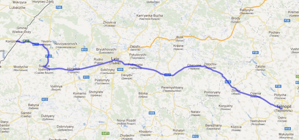
Deel 2 verder de Oekraïne in deels over de snelweg! 
Along the Highway (!) on into the Ukraine


Deel 3 

Deel 4

Deel 5

Deel 6 tot aan de Russische grens. 
Until the Russian border

De afstanden en de te verwachten klimmeters 
The distances and the expected climbing meters

Als ik de verhalen moet geloven, en dat doe ik natuurlijk, van Wouter, dan is de Oekraïne een heel arm land met een infrastructuur die nogal in verval is. Er is gewoon geen geld voor!
Ook is de staat van vervuiling van land en lucht bijzonder hoog.
Er hangt een brandlucht in de lucht en bermen zijn bezaaid met afval.
De bewust wording van de omgeving moet nog fors groeien

Volgende verhaal over het Russische gedeelte van de route.


Now also in English for the first time on this blog!
The next country is Ukraine.
The country in which a part of the football World Cup has been played last year.
An unknown country where I will go cycling.

The language is very hard to understand for me because it and has the Cyrillic characters.
This became very clear when  I received the three maps that I ordered over the Internet.
The scale is 1:500,000 and it does have 3 maps of the country and are very different with my planned itinerary (which has Latin words for the cities) in GPSies.com!

However, I have to use the maps. Indeed, the GPS device and route is and will always be additional. The route will be collored on the map before departure in 2014.

Last weekend, I was using the website www.wereldfietser.nl and came into contact with two people who have cycled around in Asia.
Wouter together with Paul, cycled by bike ​​from the Netherlands to Shanghai!
The route they followed was certainly a different one than I want to follow. Their experience is very recent (2012) and highly valuable for me!

I printed their blog out entirely and just read for the first time. Very nice and interesting! http://www.cycle2china.com

Then the route I created:

Below are the various sub maps from my planned route.
The roads are ranging from good to very poor, I understand from Wouter's story.
I expect it to be prepared by the Quest higher on the wheels turn (higher ground clearance) and very good tires. Also moderate the speed will help to ensure that the route to ride can be done with the Quest!


If I have to believe the stories, and I do, of course, the Ukraine is a very poor country with an infrastructure that is somewhat in decline. There is simply no money for that!
Also, the state of pollution of land and air is particularly high.
There is a burning smell in the air and roadsides are littered with trash.
Creating awareness of the environment has yet to grow substantially!

Next blog entry will be about the route in Russia.

maandag 10 december 2012

Mijn blog in het Japans / Engels!?

Een verassing die ik vandaag daadwerkelijk vond.
De beloofde vertaling van mijn weblog in het Engels Japans!

Nadat Ymte / Velomobiel mij met de Japanse berijder van een Strada had verbonden, ben ik gaan mailen.

Dat is een geweldig leuke ervaring!
Hij spreekt alleen Japans en niet veel Engels.
Mijn (Engelse) mail wordt dus vertaald in het Japans.
Deze vertaling is zeer matig van kwaliteit en geregeld wordt ik door Seidayu gemaild over een onduidelijkheid.

Vandaag stuurde hij de vertaling van mijn weblog, notabene in een heuse nieuwe weblog http://n2j2014.blogspot.nl

Ik sta paf.
Wel wat taalfouten, maar ik vind het heel bijzonder dat een Japaner dit wil doen en ook echt in de praktijk brengt!

Hij reed recent van Gifu naar Hiroschima en terug met zijn Milan. 1000 km, in 4 dagen als ik hem goed begreep!
Voor mij zeer waardevolle lokale informatie over de weg-gesteldheid, hellingen en drukte op een dergelijke route!


Ik zal blij zijn als ik in Japan kan zijn gedurende de herinneringsbijeenkomst van de atoombom op Hiroshima begin augustus. Het zal aanpezen worden, maar ik ga er voor en heb er reuze veel zin in!

zondag 9 december 2012

Polen

Het derde land waar ik door heen ga.
Het verkeer zal minder op fietsen zijn ingesteld.
Er vallen vele verkeersdoden, dit is vooral te wijten aan de (smalle) infrastructuur, de rijstijl van de Polen en het drankgebruik van de bestuurders.
Ook de handhaving is matig, enkele zloty's in je rijbewijs en je bent er met een waarschuwing vanaf.

Dat houdt in dat ik:
Niet 's avonds of 's nachts moet rijden (was ik al niet van plan)
Vlag(gen) achterop de Quest zetten
Knipperlichten aan bij druk verkeer op smalle weg.

De route zelf gaat ruwweg van Gubin aan de Oder, langs de Westgrens van Polen naar Krakau.
Daar wil ik het concentratiekamp Auschwitz bezoeken en erna een bezoek brengen aan de stad Krakau zelf. Enkele "rust"dagen dus.

Vervolgens zal ik Oostwaarts rijden naar de Oekraïense grens.

Polen 1e etappe

Polen 2e etappe
Polen 3e etappe
Polen 4e etappe

De links naar de GPS site van de hele route door Polen zijn:


De afstand van de route door Polen is ongeveer 800 km en de klimmeters zijn (zeer twijfelachtig getal...) 4371 meter.
Na de tocht zal ik dit kunnen verifiëren met de actuele (GPS) klimmeters.
Het landschap is glooiend heuvelachtig. 

De taal is natuurlijk Pools, iets waar niets van te maken is in vergelijking met de talen die ik ken.
Dat is verderop een veel groter raadsel en geen probleem.
Gebarentaal is internationaal en ik kom dan wel uit.

De etappes die ik denk te rijden zullen zo zijn dat ik in zuid Polen enkele rustdagen zal kunnen nemen.

Inmiddels heb ik de totale afstand naar Shanghai uitgezet.
13.500 km en dat wil ik in 4 maanden rijden.
Dit houdt in dat ik 110 km gemiddeld moet rijden en dat elke dag.
Om rustdagen te krijgen moet ik meer rijden om die te "verdienen".
Haalbaar maar pittig.

IK HEB ER ZIN IN!


Poland

The third country I will go to and through is Poland!
A country I visited earlier by plane.
On that occasion I did drive by car and did see that this country is less used to cyclists.
There are a lot of road casualties, due to the narrow roads, fast driving and alcohol while driving!
Also enforcement of the law is not very good.

This will result in me:
Not cycling in the evening or night.
One or two flags on the Quest,
Driving with flashing lights when on a narrow and busy road!

Roughly the route is from Gubin on the river Oder at the German border, Along the Westside of the Polish border south towards Krakau.

There I will visit the concentration camp (during WW2) Auschwitz and the day after that a visit of the city Krakau itself.

After these resting days I will go East towards the Ukrainian border.

The link to the whole route through Poland is:


The total distance in Poland will be800 km and the climbing meters are (doubtful!) 4371 meters

After the trip I will verify these facts with the real figures (GPS)
The landscape will be rolling / little hilly.

The language is Polish (of course) and nothing I know about languages I can compare it with.
But non-verbal communication will always be possible

The daily distances will be longer than 100 km a day.
In the mean time I made the entire route to Shanghai.
It will be 3.500 km, which I will cover in 4 months.
This means that I will have to ride 110 km a day average (without resting days).
This also means I’ll have to earn my resting days by making longer cycling days than 110 km in order to build up resting days.

dinsdag 27 november 2012

Duitsland land nummer twee

Vanaf de Nederlandse grens heb ik de route zo gezocht dat ik vrij vlak naar de Poolse grens rij.
Onderweg verwacht ik wild te kunnen kamperen.
Hierbij wil ik de Quest afdekken met een grote tarp. Binnenkort zal ik dat eens uitproberen, de tarp heb ik al.
Hierbij de link van de hele route:
http://www.gpsies.com/mapFolder.do?id=13595

En de afbeeldingen van de afzonderlijke delen:

Deel 1 Duitsland

Deel twee Duitsland
Deel 3 Duitsland
Deel 4 Duitsland tot de Poolse grens


Ik verwacht wel wat hindernissen in Duitsland, fietspaden die hoog liggen, niet op de weg (mogen) fietsen, andere route moeten nemen.
Allemaal overkomelijk.
Heb je ervaringen  met een velomobiel in Duitsland geef de tips door.
Route aanpassingen, naar aanleiding van bekendheid in die omgeving, geef ze ook graag door, dan verwerk ik deze zo mogelijk.

Inmiddels heb ik de route deels verder klaar voor China. Wat heb ik zin om te gaan. de afzonderlijke foto's van de betreffende route zijn zeer veelbelovend! Daarover later in deze blog.


Germany, country number two.

From the Dutch German border I tried to find the route which is fairly flat towards the Polish border.
North of the Hartz (low) mountain range and south of Berlin.
At night I expect to do some stealth camping, camping in the woods and medows I find.
During camping I will use “a tarp” to cover the Quest. I’ll have that tarp already and will find out how this will work out.
Now I will give you a link to the total track of Germany.


Also some images of the separate parts of the total track

I do expect some “problems” in Germany. Cycle paths who can be high, not able or allowed to cycle on the road, forced to chose another route.
All things I can deal with>
If you have any experience with a velomobiel in Germany, tell me your experience, it can help me.
Also route changes, if you are known in the surroundings please let me know so I can change the route.

In the meantime I finished the route for China. Boy, I am so eager to start! The pictures of the route (Google Streetview) are promising. I will write of this later on!


woensdag 21 november 2012

Nederland 1e deel naar Japan

Natuurlijk begin ik met fietsen in Nederland.
De route hiervoor heb ik wel klaar.
Via GPSies kun je hieronder zien hoe dit gepland is.

2e deel http://www.gpsies.com/map.do?fileId=gblmagkojoihfrlq
Geef rustig commentaar, immers goede tips zijn altijd welkom.
Ik kijk en zoek naar zo min mogelijk klimmeters. Maar ga ze niet voor elke prijs uit de weg.
Immers ik krijg zeker te maken met onverwachte (Lastige) klimmetjes tijdens de reis.
Onderweg bouw ik conditie op om deze klimmetjes uiteindelijk normaal te kunnen nemen.
Ik weet dat het klimmen met een Quest lastiger is. Immers wel wat meer dan een "gewone" reisfiets.
Hoewel met ongeveer 20 kg voor mijn Condor destijds, is de Quest een kilo of 10 meer denk ik.
Op zo'n reis is snelheid natuurlijk geen issue.
Klimmen is een kwestie van goede verzet en rustig door peddelen.(of -ploeteren).

Wel zoek ik naar een lekkere doorgaande route. Niet te veel keren en wenden. Dat is met een (dan zwaarbeladen) Quest niet echt een feest.


Een schermafdruk (poging) van het tweede deel.
Een aantal klimmeters van 584 meter (?) en een afstand van 117 km tot aan de Duitse grens.


Het eerste etappe is vanaf Katwijk.


Immers het is maar 107 km en leuk om vanaf de Noordzee te starten.
Heel vreemd is dat de etappe heel veel klimmeters geeft; 369 meter, veel meer dan je verwacht voor een dergelijke Nederlandse vlakke route.

Bij het maken van de andere (nog te tonen) etappes in de andere landen, ben ik geneigd de klimmeters met een korrel zout te nemen van de GPSies website.

Overigens zijn de "etappes" die ik maak op GPSies geen dagetappes.
Het geeft me een indruk wat de globale afstanden zijn.
Het geeft een indruk van het profiel van klimmen en dalen.
Ik kan de etappes als Tracks in de GPS zetten waardoor ik overal weet welke richting ik moet.
Vooral een stad in de goede richting uit rijden is soms erg lastig omdat je je niet kunt oriënteren.
Ook het maximaal aantal punten in een dergelijke track bepaald de lengte ervan.

Zo weer een stukje van de blog bevoorraad.


The Netherlands the 1st part of the trip to Japan

Of course I start cycling in the Netherlands.
This part is ready to use.
In gpsies.com you can see how it shows.


Please comment on the route, good tips are always welcome!
I plan the route with as less climbing meters as possible. But if I have, I will climb every hill that is necessary.
I will definitely have to deal with hills and mountains after all along the way.
Also I will build up a good physical condition when I do these kilometers and hills I encounter.
I know climbing with a Quest will be harder, it weighs a more than a standard touring bicycle.

With my condor in 2008 its weight was more than 22 kg. A Quest will be about 10 kg more to start with.
On a journey like this, speed is not an issue at all, it’s more comfortable and easier with headwinds.
Climbing is something of a good gear ratio and steady paddle (or dabbling).

I am searching for a good route without too many bends. These are hard with a Quest, this bicycle has a quite large turning circle.

The first tryout of a screen print of the second half (of the Dutch part)
With a total climbing meters of 584 meters (??) and a distance of 117 km all the way until the German border.

The first half (of the Dutch part) is from Katwijk, which is a town at the North sea.

I thought it would be nice to start from the North sea (from sea to sea), this is only 107 km from my hometown!
The climbing meters are too high is my opinion. It is virtually flat as a pancake. 369 meters is way more than can be expected for this route.

Therefore I am reluctant to believe the climbing meters of the other countries with the GPSies website!

The tracks / routes I create in GPSies are NOT daytrips. Only the maximum number for the track (500) are leading in making that part.
It also gives me, next to the distance, a measure of climbing and descending of that part of the route.
Also it is quite handy if you have created this track, to know in which direction you have to leave the city! It’s always easy to go into a city, but often very hard to know the right way out of that same city!

With the tracks I know in which direction I’ll have to go on my route. Although the route isn’t solid, I can make an alternative way anytime, anywhere!

Well, another part of the trip is ready and on the blog.


maandag 19 november 2012

Foto's niet zichtbaar....

Hallo allemaal,

Ik had in het vorige bericht enkele foto's geplaatst en kan ze op de een of andere manier niet meer zien. Dat kan liggen aan  mijn safari internet browser, maar op Chrome doet hij het ook niet.
Misschien weet iemand een oplossing?

Als proef op de som plaats ik nog een plaatje om te kijken of deze wel blijft bestaan!?

 Gobi kopie (van het bureaublad)
Gobi .gif (van het bureaublad)

Als alles goed is ga ik door een randje Gobi desert! Warm hoor.....


Pictures that aren’t visible

Hello everybody,

In my last blog entry I posted some pictures and can’t see them again. this might be caused by my web browser Safari, but in Google Chrome it isn’t working either!

Does anyone knows a remedy?

With the next testcase I will try to find out;
One picture with .copie and the same picture .gif

If all goes well I will touch the Gobi desert on my planned route, it will be quite warm……

Route keuzes

Hoe pak je zoiets aan?
Welke zaken MOET je meenemen en wat (vooral) laat je thuis?

Mijn reis met de condor in de VS en Canada is gegroeid met als basis de TransAm als middenstuk en de rest eraan vast "geplakt".
De kaarten hiervoor waren er al en zeer goed bruikbaar voor elke fietser.

Nu is alles anders.
De talen, op het Duits na dan, spreek  en versta ik niet.
De geschreven tekst zal ik in de landen niet kunnen lezen.
Dit alles maakt de ervaring des te intenser.

De route die ik plan is onbekend.
Ik ga kaarten meenemen van de betreffende landen met daarop de getekende route.
De gekochte kaarten van de Oekraïne gaf al direct een probleem.
De plaatsen waren in het Oekraïens / Russisch.
Daarvoor heb ik veel tijd om de route in te tekenen en de plaatsen te herkennen op de borden onderweg.
Nu ben ik bezig de route te plannen in www.gpsies.com onder de naam menno58.
Dat geeft me straks een steun als ik onderweg ben.
Want de GPS gaat nu mee, voor het eerst op een dergelijk lange reis!

Alleen de betreffende kaarten is nu nog een probleem.
Deze kan ik bij Garmin deels wel kopen, maar ze hebben niet alles en zijn duur. (en kwetsbaar!)
Inmiddels heb ik de site ontdekt van http://www.openstreetmap.nl 
Hier zal ik de komende tijd uitvinden om de kaarten te gaan downloaden voor gebruik onderweg.
Ook kan er een extra kaartje mee gaan omdat ze nogal kwetsbaar zijn. (al ontdekt bij een gekochte kaart van Garmin zelf, erg balen!)


De afstand die je met een Quest kunt afleggen in gevarieerd en onbekend landschap is moeilijk in te schatten.

Nu heb ik gedacht dit (als rekenmethode) op 100 -110 km te zetten.

Ik denk dat er bij goede omstandigheden makkelijk hogere afstanden kunnen worden afgelegd.
In de VS reed ik met de condor gemiddeld 89 km.

Als ik met te hoge afstanden ga rekenen zet ik mezelf onder druk. Dat is wat ik in elk geval niet wil.


Beide foto's zijn uit Kazachstan op de weg van Astana naar de Chineese grens. Het geeft een redelijk beeld van de omgeving en de weggesteldheid deels geasfalteerd en deels gravel.

In de komende berichten zal ik de afzonderlijke landen de revue laten passeren.
Hopelijk zal ik dan ook meer info hebben gekregen van Wim Rutten die naar Moskou en terug is gereden, maar ook naar de Oekraïne en terug is geweest met de Strada!


Choices of the route

How do you do this?
Which items must you take with you and what to leave home (even more important).

My trip with “the Condor” (a Dutch recumbent of Optima) in the USA and Canada is grown from the TransAm as a centrepiece and the rest was attached later.
The maps for this trip were bought from Adventure Cycling Association and are very useful for cyclists.

Now everything is completely different!
The languages, I do not speak or understand them at all, except for the German language.
The written text in those countries I can’t read;
Cyrillic (Russian), Chinese and Japanese characters are a complete mystery for me.
This all makes this trip even more intense!

The situation on the route is completely unknown for me.
By this I mean; road condition, hills, mountains, steepness of them, intensity of traffic, all unclear.
I will have the maps of the countries I travel through. On these maps I will draw my route.
When I bought the maps of the Ukraine, it became clear that I can’t read the city names. My planned route with gpsies was using the “normal” ways of spelling for western orientated people.
Now I will have to make myself known of the way this language is used. So I can read the signs along the route.

Next to the maps I will carry a GPS device.
My planned route will be on this device and support me in taking the right way.
In cities it can be very hard to know what way to take. A GPS with the route on or in it will prove to be valuable!
For the first time this GPS will be with me on a long trip like this!


Only the digital maps are a problem (at this moment).
I can buy them at Garmin, but they don’t have all the countries I travel through and are expensive and vulnerable.
I found a website which can be very helpful with this problem!
Here I can find out which map to chose and download these maps.
After putting this maps on a MicroSD card I can duplicate these, because they can fail along the way.

I bought one map of Garmin and it failed, I can throw this one away, a waste of money €89 a lot of money!

The distance I can cover with a (fully loaded) Quest is difficult to estimate, due to variety of landscape, hills and busy traffic?

Now I thought of using a distance of 100 – 110 km to make things clear about the time I need to come to Shanghai in time.

In the USA and Canada in 2008 I did an average of 89 km with my two wheeled (heavy) Condor.

If I use to long distances I put myself under a lot of pressure, I want to avoid that!


vrijdag 9 november 2012

start nieuwe blog!

Nu de reis met mijn Carbon Quest steeds vastere vormen begint te krijgen, start ik vandaag 9 november 2012 een nieuwe blog.

Hierin zet ik de direct gerelateerde informatie en vorderingen van de grote reis in 2014.

Nog nooit is een Velomobiel op deze manier gebruikt en ik ben ook erg benieuwd hoe het in de praktijk zal gaan.

Ik heb enige ervaring in lange fietsreizen met de ligfiets.
In 2008 reed ik in 5 maanden en een week bijna 11.000 km door de VS en Canada. Een erg inspirerende reis die nu in met weer een ligfiets (nu een driewielige Quest!) vanuit Nederland naar  Japan.
Omdat ik dit keer niet wil vliegen, zal ik met de Trans Siberië Express terug reizen naar Nederland.
In Japan zal ik de Quest op een vrachtschip zetten voor zijn terugreis.

De terugreis van de Quest is helaas erg kostbaar.
Daarvoor ga ik proberen een specifieke internationale sponsor te vinden voor reclame op de Quest.
Hierdoor zal deze exposure krijgen bij aandacht (die ik zeker zal trekken) van de pers in de landen die ik doorfiets.

De route wordt nog door mij uitgewerkt op www.gpsies.com Dat resulteert tot nu toe in een afstand van ruim 8700 km tot aan de Chinese grens. Uitwerking van de route wordt op deze weblog vermeld zodra deze klaar is. Eventueel kun je de route t.n.t. opzoeken op bovenstaande website onder de naam menno58.

In de loop van de tijd zal ik allerlei zaken verder uitwerken mogelijk op thematische basis.


Start of the new blog!

Because the new trip with my Quest Carbon will be more certain I start today, November 9th, with a new blog.

In this blog I will give direct related progress and reasons of why I made certain choices of the trip to Japan.

Never a Velomobiel is used in this way. I am therefore very curious how this will go when I am on the road with it.

I have some experience in long travel by recumbent.
In 2008 I did a 11.000 km long trip in the USA and Canada.
A very inspiring trip which resulted in a new plan;
From the Netherlands to Japan (last leg by ferry of course)
Because I don’t want to fly back I would like to use the train to go back to the Netherlands. In China I will use the train to go from Shanghai to Beijing. From there I will use the Trans Siberian Express to go to Moscow. From there I will use the train again to go to the Netherlands again.
The last leg isn’t named the Trans Siberian Express of course.

Before I leave Japan I will send my Quest back home by boat.

Until now the price of sending back my Quest is proved to be very high.
For this I hope to be able to find a (international) sponsor so this will reduce my budget of this trip significantly!
This sponsor will have a lot of exposure of his name. I think I will have some attention along the way. Maybe even newspaper, magazines or TV.

The route I still work on the route I plan to take. I do this planning on www.gpsies.com under the username menno58.
Until now I finished the route until the Chinese border. This is 8700 km.
On the blog you will see these parts (of every country) when I finished planning.
If you like you can find the route (s) here.

In time I will work out details on the blog, every time I will use another theme for more information.